Thursday 29 February 2024, 10:09 - Last updated: 2 March, 08:51
The bad weather continues in Italy. The disturbance that has affected the peninsula during this week will end by tomorrow evening (March 1st), but will immediately be replaced by a new wave coming from the North Atlantic, which will first involve Spain. There, it has been renamed Storm Dorotea. "The rainy, disturbed, and cyclonic phase is not over yet, so it will last also in the coming days," explains Edoardo Ferrara, meteorologist at 3bmeteo.
What to expect in the coming days
During this week, we have been affected by a cyclonic vortex that is now concentrating its major effects in the Central-South. In the North, we are witnessing a partial respite with local rains, without the same intensity of the past days.
"However, it will be a short respite," says Ferrara. "Already from tomorrow, it will start to rain more widely - the meteorologist continues - once again also over Northern Italy." Until tomorrow, we will deal with this cyclonic circulation that currently has its center south of Sardinia.
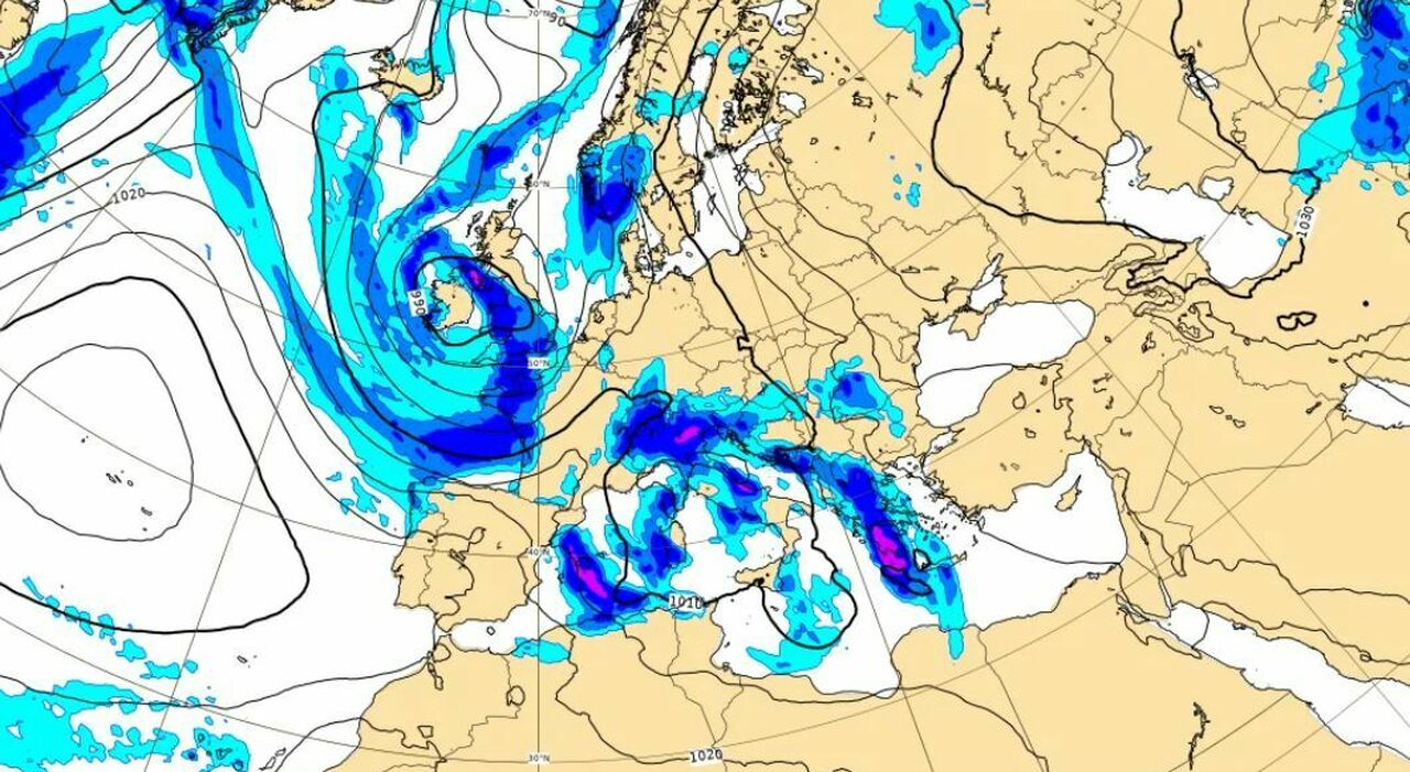
Over the weekend, a new disturbance will arrive, which is linked to the cyclone over Iceland. It will also hit Spain, where there will be colder air and snow on the mountains. This disturbance will also affect Italy, particularly during Sunday, when a phase of marked bad weather is expected again in the North, with more intense phenomena in the North-West (the North-East will also be involved) and progressively also on the Tyrrhenian side and in Sardinia. While in this phase, over the weekend, the middle Adriatic and the south will see a drier break with very sporadic phenomena.
Snow situation: avalanche alert
Snowfall is also expected in Italy. By tomorrow, snow will also fall in the Apennines, generally at high altitudes (above 1900-2100 m), but also at 1200-1400 on the central-northern arc. As for the Alps, there will be a lot of snow especially on the western ones (Piedmont and Aosta Valley), but also on the rest of the alpine arc, on Sunday.
Meteorologist Ferrara specifies: "In particular in Piedmont and Aosta Valley, up to 1 meter of further fresh snow may fall from 1800 to 2000 meters of altitude. By Sunday, the total accumulations on the Alps could exceed 2-3 meters above 1900-2000 meters of altitude," and he reports "a high avalanche danger at least until next Monday - Tuesday. There has already been an avalanche yesterday with a victim in South Tyrol, but it is likely that this is just the beginning and that there will be other discharges in the coming days. Pay maximum attention."
The Iceland cyclone and Storm Dorotea
The expert clarifies about the disturbance that will affect our peninsula in the coming days: "Formally, the Iceland cyclone will not reach Spain and Italy. The Icelandic cyclone will guide a disturbance that will be responsible for a new phase of bad weather. So there is a link, but that cyclone will remain between Iceland and the British Isles. Storm Dorotea, which has hit Spain in these hours and is linked to the Iceland cyclone, is the one that will instead move to Italy. The pivot of the cyclone remains on the British Isles, but the entire associated cloud front will descend involving Spain, France, and Italy. So, we are talking about a new wave of bad weather coming, which will replace the one that is closing in these hours."
How long will the bad weather last in Italy?
"At least until the beginning of next week," explains Ferrara: "Even Monday will be a disturbed day over much of Italy. While Sunday the disturbance will act mainly in the North and on the middle Tyrrhenian side, by Monday it should also reach the rest of the peninsula.
From there on, the situation becomes a bit chaotic, but generally from Tuesday onwards the weather will still be quite dynamic, occasionally unstable, but not necessarily rainy as in these days. We might have some scattered showers, alternated with partially sunny dry breaks, in a colder climate context especially in the North. The acute phase of bad weather will therefore end on Tuesday, still leaving unstable remnants (high pressure does not return)."
Temperatures dropping
In these days, despite the bad weather, the temperatures have often been above the averages for the period. The snow in the Apennines is at very high altitudes and also on the Alps is above 1300-1600 meters. The meteorologist speaks of "a situation more autumnal than winter." Next week, the temperatures should drop: "nothing exceptional, but with a more winterly connotation compared to what we are experiencing these days, especially in the North. In these days despite the rain the temperatures have remained high for the period. Therefore, the weather, from Tuesday, will become more variable but climatically it will tend to be colder compared to these days."
© ALL RIGHTS RESERVED
This article is automatically translated
